I once remember when Charlene Gonzales represented the Philippines in the 1994 Miss Universe and was asked by the host if how many islands does Philippines have, and she answered back by asking the host the famous line "High tide or low tide?"
That made Charlene Gonzales popular on the said competition and debate raised after that. If she should answer the question by giving another question. Nevertheless, it's not really important as much as we need to be more proud of how our country is blessed with so many natural, beautiful, magnificent and world class paradise that would boast its current tourist tagline "It's More Fun in the Philippines".
Having fun doesn't only implies being satisfied with the attractive tourist destinations, might as well on the possible activities, hang-outs and souvenirs but more on the accommodation, hospitality and the over-all representation of the said tourist spot.
Primarily, tourism is business. We are selling our country to ensure that foreigners, or what we called tourist or traveler may consider the Philippines to be part of their tour. However, as Filipinos, we must set a very good example, that before we take on our back pack and booked tickets for international flights and travel around Asia or Europe, we able to explore the beauty of our own. That every Filipino must oblige to follow such rule, if we really loved our own.
Philippines, is an archipelago composes of 7, 107 islands, however, only 2000 islands have been inhabited.
These islands are categorized under the three major island groups namely:
LUZON - the largest and the northernmost part of the country, and houses the
country's capital and largest city, Manila. It is also the world's
fifteenth largest and the fifth most populous island. Luzon is
economically and politically the most important island of the country as
it leads Philippines, both in industry as well as agriculture.
VISAYAS - forms the central portion of the Philippines archipelago and comprises a
cluster of islands. It is the most popular part of the country and is
well-known among tourists due to its rich natural resources. Its central
location makes it an important economic and political link between
Luzon and Mindanao.
MINDANAO - the second largest island of the Philippines after Luzon, completes the
Philippine archipelago by forming its southernmost part. It is endowed
with rich mineral resources such as lead, zinc, iron, copper, gold,
chromite and magnetite. Nearly half of Philippines gold reserves are
accounted from Mindanao's gold mines.
After surfing the net, I gather here some beautiful tourist summer island destinations that we may consider:
CAMIGUIN ISLAND (the Island Born of Fire) - It has been known as
a volcanic island since it has seven volcanoes unmatched anywhere else in Southeast
Asia and one of the volcanoes there has been unpredictably active which is the
Mt. Hibok-hibok. Volcanic eruptions and land movements have created this spectacular
island full of natural wonders and historical riches.
PAGUDPUD - (PAH GOOD POOD) is an enormous place
to visit if you're looking for the comparatively perfect charms of the Philippines.
Pagudpud is a wide and beautiful town on the northwest tip of Ilocos Norte,
Luzon, bounded to the south by the town of Bangui and to the east by the Cordillera
Mountain Range, the town of Adams and the province of Cagayan. The South China
Sea lies to the west and north.
It is considered the largest island
in the Philippines. The hills and mountains are luxuriant, the valleys productive.
It lies 45 miles north of Laoag City, the provincial capital, and about 350
miles north of Manila -- about the equal distance between Los Angeles and the
San Francisco Bay Area. Creeks, streams and waterfalls splash the landscape
and spill into the South China Sea. All around, the ocean and sky are awash
in varying shades of blue.
CAPONES ISLAND (San Antonio, Zambales) - one of the main attractions in Pundaquit Zambales. The island is
actually a big lump of rock formation with very little soil. Beaches
around the island aren’t that homie for the usual tourist mainly because
of the sand and rock mixture from the crashing waves of the open ocean.
POTIPOT ISLAND - located roughly 1 km from the mainland shore of Uacon, Candelaria, Zambales. Uacon is about 240+km from Manila by road.
Some of the attractions of Potipot Island are: its white sands that
completely surround the whole island, the calm clear waters, its
proximity to the mainland that allows visitors to reach the island in
only 5 minutes by banca, the lush vegetation and trees that provide
shade along the beach (and even on the water).
There are no resorts on the island. Visitors usually stay at the
resorts on the mainland in Uacon where they hire bancas to take them to
Potipot.
CABAGLETE ISLAND - is one of the best tourist destinations in the Mauban, Quezon Province. Located
in the Lamon Bay fronting the Pacific Ocean, a paradise that will hook
you up with its marine diversity, flora, fauna and incredible wave of
sands during the low tide.
Cagbalete Island is such a paradise. The blue-water is so clean
and it’s surrounded by the white sands. With the abundance of the unique
species of plants, Cagbalete is the place for all nature lovers.
BATANES ISLAND - a Philippine province comprising ten islands that are located in the Luzon Strait between the islands of Luzon and Taiwan. It is the northernmost part of the Philippines and is also the smallest province both in terms of population and land area.
ANAWANGIN - Anawangin Cove is in the province of Zambales, facing the South China
Sea. It can be reached via half an hour boat ride from Barangay
Pundaquit or San Miguel in San Antonio, Zambales or via a four to six
hours trek of Mt. Pundaquit
BUSUANGA ISLAND PARADISE - the largest island in the Calamian Group in the province of Palawan
in the Philippines. Busuanga Island is, in fact, the second largest
island in the province after Palawan island itself. The island is
located halfway between the islands of Mindoro and Palawan with the South China Sea located to the west and the Sulu Sea to the southeast. South of the island are the two other major islands of the Calamian Group: Culion Island and Coron Island.
CATANDUANES - "Isla de Cobos" was Catanduanes' first adopted name. It was earned as
such during the early part of 1573 when Spanish conquistadores came
upon several tribes living in the thatched huts called cobos.
Catanduanes, is a hispanized term derived from the word tandu, a
native beetle and the samdong tree, which were both found in abundance
throughout the island. Common reference to "katanduan" or "kasamdongan",
meaning a place where the tandu or the samdong tree thrives in
abundance, led to the coining of the word Catanduanes is the land of the
howling wind of the north too.
CORON ISLAND - the third largest island in the Calamian Group of Islands in northern
Palawan in the Philippines. The island is part of the larger municipality of the same name It is about 170 nautical miles (310 km) southwest of Manila is known for several Japanese shipwrecks World War II vintage. The island is part of the ancestral domain of the indigenous Tagbanua people. Known as Calis among the Tagbanuas and Coronians, its Tribal Chieftain is Apo Rodolfo Aguilar.
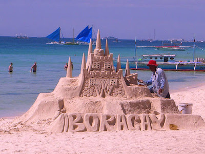
BORACAY - Anyone who hasn't been to the Philippines will want to see the best that
the country has to offer. A common impression is that it's in the
Pacific so you can imagine palm trees, neat little huts, white sand
beaches, beach beds, nice chilled or iced drinks to compliment the
weather, and the beautiful ocean. If that is your first impression of
the country then you get the chance to fulfill the fantasy by heading
out to Boracay.
MARINDUQUE - usually, this island province is associated with the Moriones Festival
the trademark revelry and tourist magnet of the island. For some,
Marinduque is also a reminder of a grim past when mining was an
important industry in the island – an industry which took a toll on its
environment and locals. But there is more to Marinduque than just
Moriones and mining. It is a treasure trove of surprising and awesome
finds.
CORREGIDOR - a small rocky island in the Philippines about 48 kilometers west of Manila which
is stragetically located at the entrance of Manila Bay. This island fortress stands as
a memorial for the courage, valor, and heroism of its Filipino and American defenders who bravely
held their ground against the overwhelming number of invading Japanese forces during World War II.
Also known as "the Rock," it was a key bastion of the Allies during the war. When the Japanese
invaded the Philippines in December 1941, the military force under the command of Gen. Douglas MacArthur
carried out a delaying action at Bataan. Corregidor became the headquarters of the Allied forces and also the
seat of the Philippine Commonwealth government. It was from Corregidor that Philippine President
Manuel Quezon and General MacArthur left for Australia in February 1942, leaving
behind Lt. Gen. Jonathan M. Wainwright in command.
There are still many islands that I have not yet included here. Maybe next time, I will complete the list. So let us enjoy Philippine's most well-known destinations to prove that It is really indeed MORE FUN IN THE PHILIPPINES.


Walang komento:
Mag-post ng isang Komento